Search
Close this search box.

Okaloosa County placed under ‘Slight’ risk as Tuesday storm approaches

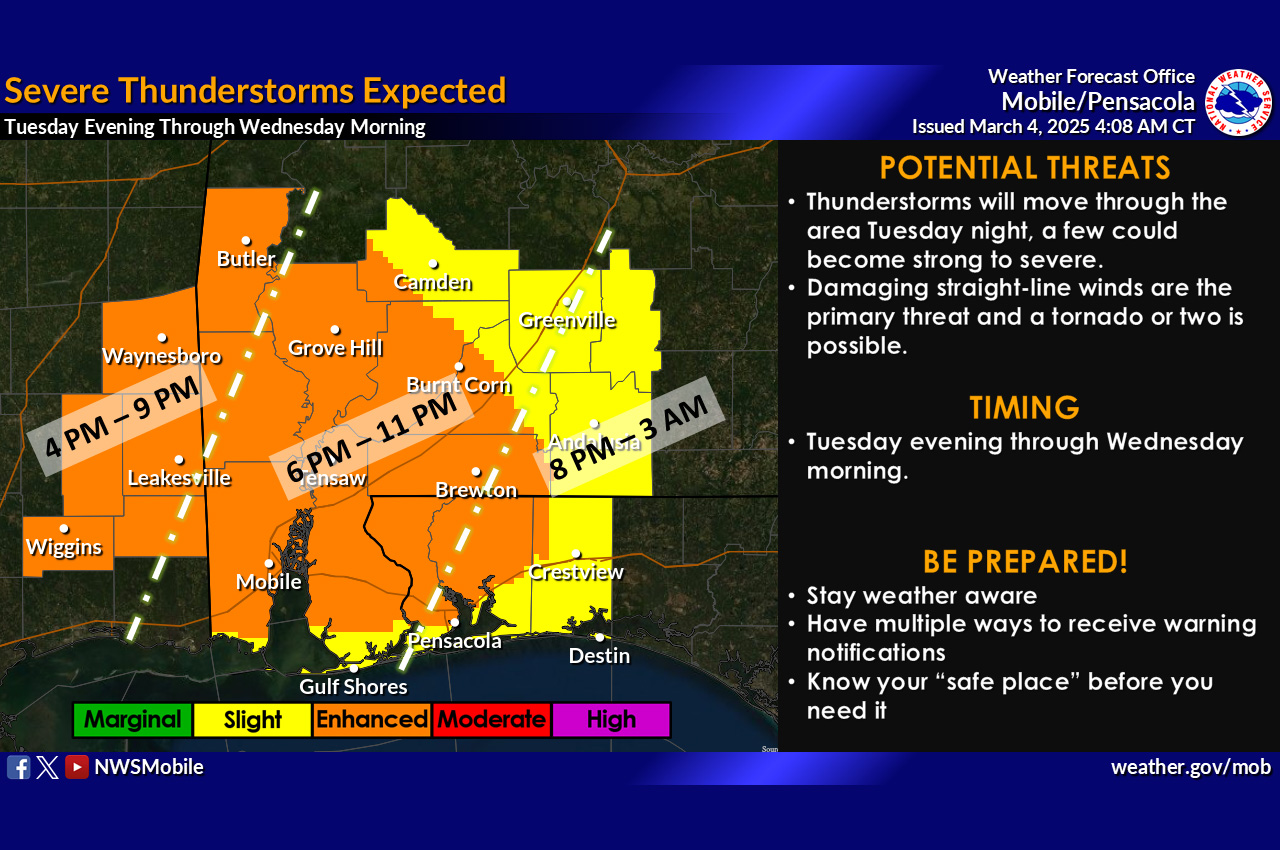
Forecasters now predict storms to sweep through the area Tuesday evening until 3 a.m. Wednesday, with winds up to 60 mph and possible tornadoes as the main threats.
NWS

Okaloosa County emergency officials have updated their severe weather outlook, placing most of the county under a “Slight” risk category for the approaching storm system.

  • According to a Monday briefing from Okaloosa Public Safety Director Patrick Maddox, the “Enhanced” risk area now extends to the county line and possibly into the northwest portion of the county.

The latest forecast indicates a line of storms will develop and move west to east Tuesday evening through approximately 3 a.m. Wednesday. Maddox said the greatest threats are winds reaching up to 60 mph and the possibility of a few tornadoes.

“Non-thunderstorm winds ahead of the main line of storms in the 35-40 mph range are likely for a long duration, making limb-fall from weekend trees a possibility,” Maddox warned.

Additional concerns include elevated rip currents and surf heights up to 10 feet beginning Monday night. Rainfall is expected to remain under 1.5 inches as the system is forecast to move quickly through the region.

Okaloosa County is likely to experience the greatest impacts between 8 p.m. Tuesday and 3 a.m. Wednesday, with the eastern parts of the county affected later in that timeframe. Officials noted that some discrete storm cells ahead of the main line are possible.

  • “Confidence on storms forming is high, confidence on overall severity is less-certain, but always prepare as if they were to occur,” Maddox said.

County officials urged residents to have multiple ways to receive emergency information and to remain weather-aware as they continue to monitor the situation.

PROMOTION

Join the conversation...

Continue reading 👇

Community Comments

“Where can we find your list of all 10 questions?”
Respond
“They've done a great job. Let's consider burying lines from here on out”
Respond
Anne Porter commented on WordroW: October 14, 2026
“Having been without TV since Isiasis, give us an update on Spectrim’s progress restoring cable, please,”
Respond
“It is Wednesday morning Oct.14 and we have a downed electric pole in our front yard in incorporated Okaloosa county. So no thanks from us. We reported it when it...”
Respond
“Thank you to all the linemen who left their homes to ensure those of us affected by this hurricane got our power back. I know they worked long hours and...”
Respond
“I attended last year's casino night and had a great time. The food was delicious and the games were fun. Its also cool having an event in the Legendary show...”
Respond
“Ok, but to ignore the Chelco outages in an article gives a false impression on recovery of power outages. If you had the info, why wouldn't you report a more...”
Respond
“Thoroughly, thoroughly thank you for all the hard work and long hours to restore power.”
Respond
“What a fantastic job! These individuals travel from far away to help restore power to the people who live here and the work is long, hard and very dangerous! Thanks...”
Respond
“I for one would like to complement the crews on the power restoration.”
Respond

GET OUR FREE LOCAL NEWSLETTER

Get the weekday email that actually makes reading local news enjoyable again.