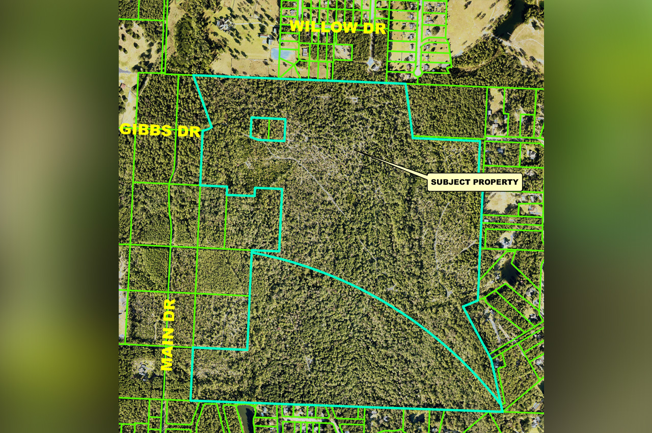
The Okaloosa Board of County Commissioners on Tuesday unanimously approved a conceptual master plan for River Park, a 392-lot single-family residential subdivision planned for 263 acres east of Main Drive and north of Airport Road in Crestview.
- The vote authorizes the developer, River Park Landing, LLC, to phase the project into three parts. It does not approve construction. Each of the three phases will return to the commission for a separate development order before infrastructure can be built.
Kristen Shell of the county’s Growth Management department presented the item.
“This is a 392-lot single-family residential subdivision,” Shell said. “It is coming to you this morning as an approval for a master plan, which means that the developer wishes to phase the project.”
Shell told commissioners the property has been entitled for residential development since 1990, with a small half-acre portion changed in 2005 to recognize the Bob Sikes Airport influence zone. The site has both Low Density Residential and Airport Compatibility future land use designations and is zoned Residential-1 and Airport Compatibility.
The first phase is planned for 63 units on half-acre lots, the minimum size allowed in the Airport Compatibility zone, according to applicant representative Matt Ables, of LJA Engineering. Phases two and three would consist of quarter-acre lots.
Chairman Trey Goodwin asked Shell to explain how a master plan differs from a development order, noting it was an unusual format for the board.
- “They do have to have all of the infrastructure installed for the phase that they seek development order approval for when they come in for that development order,” Shell said. “So it has to be freestanding basically infrastructure-wise. But it does allow them to break up large projects into phases.”
Shell said if a future development order does not match the approved master plan, the developer would have to return for a master plan amendment.
Commissioner Sherri Cox pressed staff and the applicant on whether infrastructure would be sized to handle the full 392-lot buildout or only each phase as it is approved.
“Three hundred units is a lot,” Cox said. “That’s a lot to put on any residential neighborhood.”
Shell said internal roads and stormwater would be developed phase by phase, while some larger systems would be built earlier. Ables said a lift station installed during the first phase would serve all three phases, and the project would draw water from two locations for redundancy, with additional connections added in later phases. He said the developer would pay to connect to an existing lift station near the airport that has been in place since an earlier development attempt but has gone largely unused.
Ables said the project’s traffic study warranted turn lanes on Airport Road, which the developer will install during the first phase. The developer will also pay into the county’s mobility fee program, which Shell described as the county’s version of a transportation impact fee.
Cox also asked about access for emergency responders. Ables said the development will have two main access points, plus a third emergency-only access connecting to Buckhorn Drive. Shell confirmed the Buckhorn Drive connection is restricted to first responders.
One member of the public spoke during Tuesday’s hearing, raising concerns about density, wetlands and infrastructure capacity.
- “Four hundred homes is another 800 cars,” the speaker said. “The infrastructure now, we’re 50 years behind. We’re building bypasses. It’s not gonna help. These homes, you’re building too many homes, plus it’s wetlands.”
Ables responded that the traffic study did not project all vehicles being on the road simultaneously and said the development’s water model showed adequate pressure through the third phase. Sewer service will run to the existing lift station near Airport Road at the developer’s expense, with Auburn Water and Okaloosa County providing utilities.
According to the staff agenda packet, the 263-acre site contains 64.99 acres of on-site wetlands and sits in flood zones A, AE and X. The conceptual plan includes three wetland crossings, which will require federal and state permits that have not yet been issued. A flood study for Bend’s Creek is currently under review by the county engineer.
Ables noted the property was previously approved as a 600-lot planned unit development in 2012, but said that plan was not buildable. The current proposal of 392 lots is being pursued under existing zoning.
Commissioner Paul Mixon, whose District 1 includes the property, made the motion to approve.
“I think it’s very important as a commission we remember that it was said to us by staff that this comes back to us at each step as we continue to move forward,” Mixon said. “This does come back, and so we get to see the progress and be sure that it follows what’s being said so far.”
The Planning Commission previously recommended approval by unanimous vote on April 9. Seven citizens spoke in opposition at that meeting, citing concerns about traffic, access points and wetland crossings, according to the staff agenda packet.
Each phase of the project will return to the Board of County Commissioners for a separate development order, at which point the developer will conduct phase-specific traffic analysis and pay applicable mobility fees.


One Response
I would be concerned about clear cutting the trees! It’s very sad to lose all those trees. Aren’t we supposed to be concerned about global warming, sufficient drainage and air quality? If you look at many of those new subdivisions in Crestview, the land is clear cut of all the trees. That should be criminal, and the county commissioners and the Crestview council should be concerned.