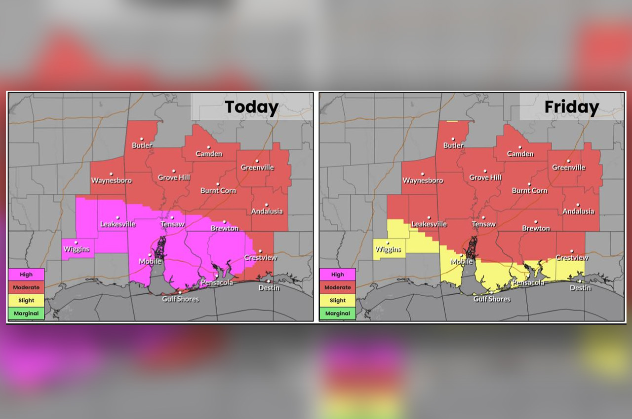
The National Weather Service in Mobile placed Okaloosa County under a moderate risk of excessive rain on Thursday, with a rare high risk issued for areas to the west including Mobile and Pensacola, as the remnants of Tropical Storm Arthur bring an additional 6 to 12 inches of rain to the region through Friday, with locally higher amounts possible.
- The agency described the broader setup as a “particularly dangerous and life threatening” event, with the highest flash flood threat occurring Thursday.
Torrential rainfall could deliver locally 15 inches or more in the high-risk zone, the NWS said, and significant river flooding is also a concern. High-risk creek beds are expected to see rapid water rises, with potential problems near roads.
The flood risk for Okaloosa is forecast to remain at moderate through Friday before easing to slight on Saturday, with the coastal areas of the county dropping to slight Friday and marginal by Saturday, according to the NWS outlook.
- A slight risk of severe storms is also in place for Thursday, with the potential for isolated tornadoes and damaging winds.
Coastal hazards are increasing as well. The NWS warned of life-threatening rip currents through Saturday and 5- to 7-foot surf from late Thursday night into Friday morning. Minor coastal flooding is possible around Thursday afternoon’s high tide, especially near Mobile Bay.
“Stay weather aware and be ready to take urgent action if flash flood warnings are issued, particularly wireless emergency alert flash flood warnings or considerable and/or catastrophic flooding,” the NWS said. “Remember, never cross flooded roads. Turn Around, Don’t Drown!”
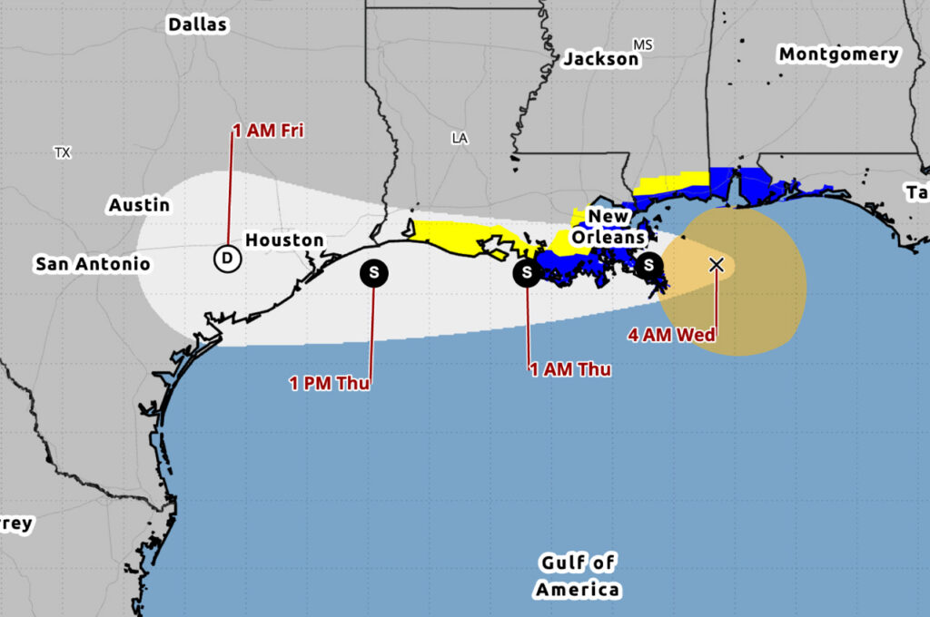
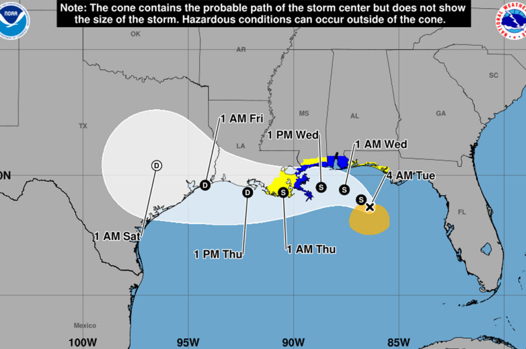
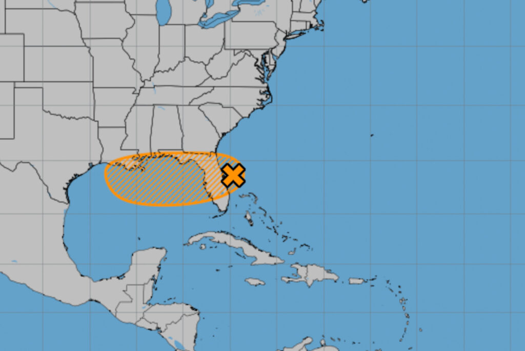
The National Hurricane Center downgraded Arthur to a post-tropical cyclone late Wednesday after the storm’s center reformed near Galveston and convection failed to reorganize. The center is expected to dissipate Thursday night over southeastern Texas or southwestern Louisiana, with the remnants moving east-northeastward across the southeastern United States and emerging into the Atlantic on Friday.
- “Even though Arthur is no longer a tropical cyclone, heavy rainfall and life-threatening flash flooding will continue to be a major hazard for the next few days across the southeastern United States,” the NHC said in its final advisory on the system. “There is also an increased tornado threat for portions of the southeastern U.S. through Thursday.”
Okaloosa County Public Safety Director Patrick Maddox said Wednesday night that Arthur is expected to track north of the area, with sustained winds above 40 mph not expected and non-thunderstorm gusts forecast at a maximum of 28 mph.
Bridge closures due to wind are not likely, he said. A cold front to the north is expected to squeeze the system and keep the heaviest rain along the northern Florida line, with the heaviest totals at the north end of Okaloosa County.
Maddox said the Southeast River Forecast Center is now projecting minor flooding on the Blackwater and Shoal rivers and the action stage on the Yellow River. The Blackwater River is forecast to reach 12.8 feet at minor flood stage by 7 a.m. Saturday, when minor flooding of secondary roads and lowlands is expected from the Highway 4 bridge downstream. The Yellow River is forecast to reach 11.2 feet at action stage by 1 a.m. Sunday, when water flows over yards on Ellis Road and minor overflow occurs in low-lying areas. The Shoal River is forecast to reach 9.2 feet at minor flood stage by 7 p.m. Saturday, when minor flooding of low-lying areas is expected, with water in yards on Sowell Road.
- Maddox said river forecasts from the Southeast River Forecast Center account for past precipitation and rainfall expected 48 hours into the future. Totals usually decrease as the forecast nears, he said, but residents should plan for the forecasted levels.
Everbridge alert messages were scheduled to go out at 9 a.m. Thursday to areas in the path of expected river impacts, Maddox said, 48 hours ahead of any forecast impact.
Sandbags are available 24 hours a day at two self-serve locations, Maddox said. Residents are asked to bring their own shovels. The North location is at Public Works, 1759 South Ferdon Blvd., Crestview, with the gate entrance on Goodwin Avenue. The South location is at Don & Susan Stillwell Park (formerly Essex Park), 714 Essex Park Road, Fort Walton Beach.
Maddox said the county does not expect to activate its Emergency Operations Center at this time but will continue to monitor the system and coordinate with strategic partners.