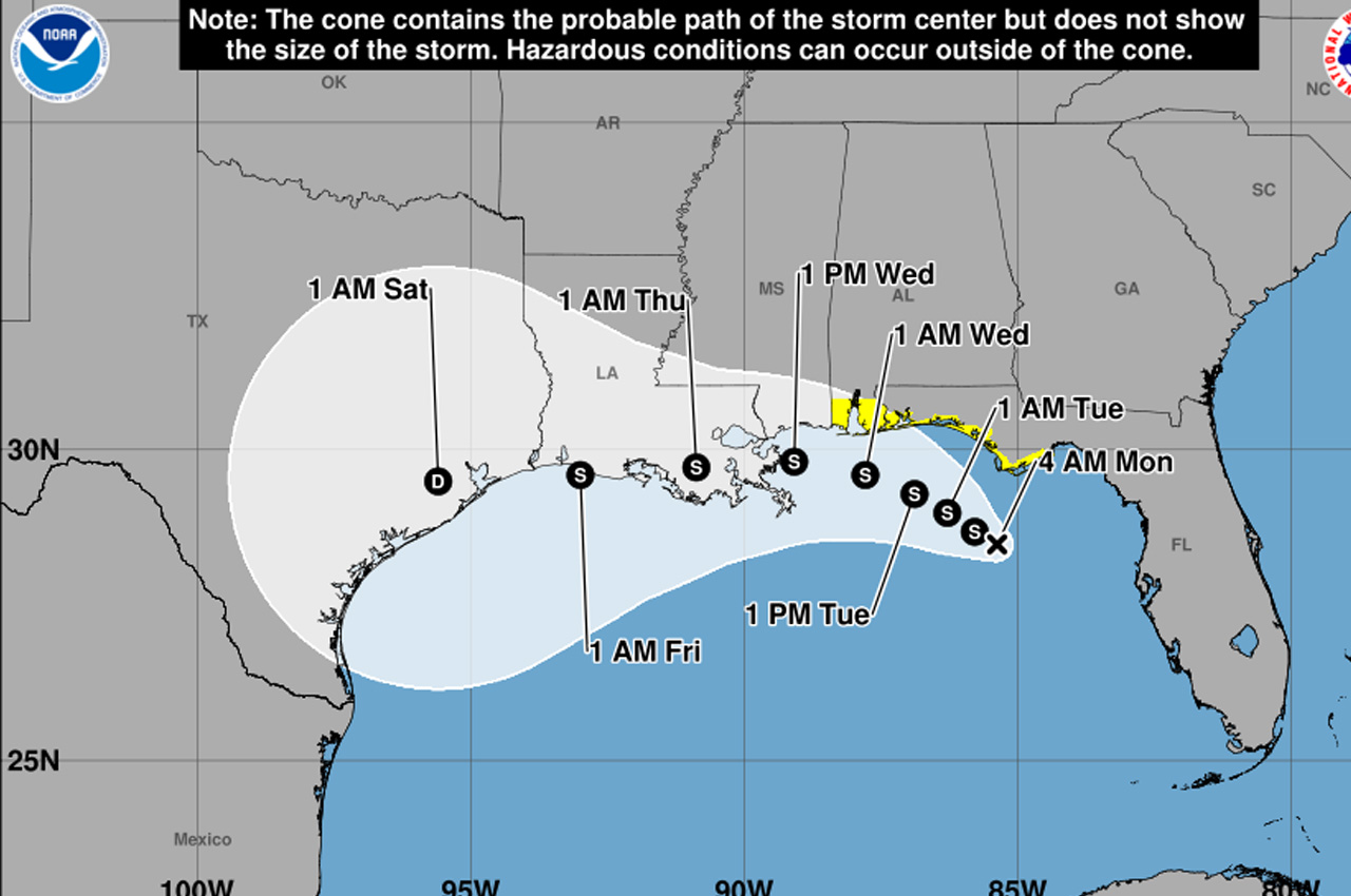
Tropical Depression Two was located about 120 miles south of Panama City early Monday morning and is expected to become a tropical storm later in the day, according to the National Hurricane Center.
- The system had maximum sustained winds of 35 mph as of 4 a.m. CDT and was moving northwest at 3 mph. A slow northwestward motion is expected over the next day or so, followed by a turn toward the west-northwest or west. On that forecast track, the depression will move near or along the northern Gulf Coast over the next several days.
The National Hurricane Center has issued a Tropical Storm Watch from the Ochlockonee River to the Mississippi-Alabama border, including a new extension Monday to the Alabama Gulf Coast. Tropical storm conditions are possible within the watch area by Monday night into Tuesday.
Okaloosa County Public Safety Director Patrick Maddox said Sunday that the likelihood of significant local impacts is unlikely based on the current forecast, though the area will still likely see training storms and marine and surf conditions.
- “On the updated track even the TS strength wind probability is sub 10% for our area in this forecast,” Maddox said.
The forecast track has shifted farther south, Maddox said, which is good news for Okaloosa County but concerning for communities farther west that are more vulnerable.
“Whatever ultimately develops is on track for New Orleans and Galveston, both very susceptible to storm surge and aerial flooding, and Texas is still paying for their last rain event,” Maddox said. “We’ve got teams out there now and are in close coordination with them.”
Maddox noted that conditions and forecasts can change quickly, and that significant uncertainty remains in the track and timing because the system had moved little in the 12 hours before his update.
Storm surge of 1 to 3 feet is possible from Indian Pass to Chassahowitzka along the Florida Gulf Coast, as well as from the Mississippi-Alabama border to the Alabama-Florida border and in Mobile Bay, according to the hurricane center.
The depression is expected to produce 2 to 4 inches of rainfall with locally higher totals around 6 inches through Friday along the Gulf Coast from western Florida to the middle Texas coast, including southern portions of Alabama, Mississippi and Louisiana. The rainfall may produce areas of flash flooding, especially in urban areas, the hurricane center said.
Swells generated by the system are already affecting portions of the Florida Gulf Coast and are expected to spread westward during the week, likely causing life-threatening surf and rip current conditions.
The next complete advisory from the National Hurricane Center is expected at 10 a.m. CDT Monday.